
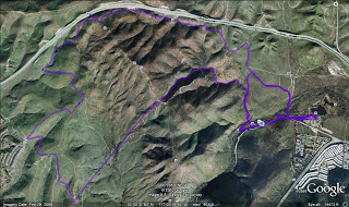
Here the satellite view from Google Map showing the trail route we took on day 2 of the Mission Trails backpack hike. You will see a very straight line in the hike, that is where we lost satellite reception when we went through a narrow valley.
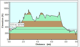
Here is the profile of the hike that day. With was generated through Garmins MapSource program. I’m not real thrilled with it so if someone knows a better way to generate this, let me know. There are some real nice verical sections, some I know were very close to verical, but maybe not as verical as this graph is showing 😉
I have the GPS data if anyone is interested in playing with it. Just reply to steven@stachwick.com and I will send it to you.
One thing to note, is that the satellite view really has the hikes from both days on it. The last day stated like the first but we cut it short. You can see where a mile into the hike we took a left and retuned back towards the dam instead of going out to boonies.